News Summary
Fort Pierce is currently under a Tropical Storm Watch as Tropical Depression Nine moves toward South Florida. With potential strengthening into a tropical storm, the region could experience gusty winds, heavy rainfall, and dangerous surf conditions. Residents are urged to prepare and stay informed about the developing situation, with updates provided by local authorities and the National Hurricane Center.
Fort Pierce Under Tropical Storm Watch as Tropical Depression Nine Approaches South Florida
The city of Fort Pierce, located along the Treasure Coast, is currently under a Tropical Storm Watch as Tropical Depression Nine continues its approach toward South Florida. The storm’s forecasted path and potential impacts have prompted local officials and residents to monitor the situation closely.
Current Meteorological Situation
The National Hurricane Center has identified Tropical Depression Nine forming between the central Bahamas and eastern Cuba early Saturday morning. Recent data from NOAA Hurricane Hunter aircraft confirmed the storm has developed a more defined circulation, with sustained winds near 35 mph. The storm is anticipated to strengthen over the upcoming weekend into a tropical storm.
Forecast models suggest the storm will move northwest, skirting just offshore of Florida’s Atlantic coast. While the storm’s center is expected to remain off the coast, significant weather impacts may still be felt along the shorelines.
Forecast and Potential Impacts
The National Hurricane Center predicts that Tropical Depression Nine will strengthen into a tropical storm over the weekend. This development could bring gusty winds, rough surf, and heavy rainfall to coastal regions of Florida, especially from late Sunday through Monday.
Additionally, the storm is projected to bring between 1 to 3 inches of rain to the area, with some localities possibly experiencing more than 4 inches. Such rainfall poses a risk of localized flooding, particularly in urban and flood-prone areas.
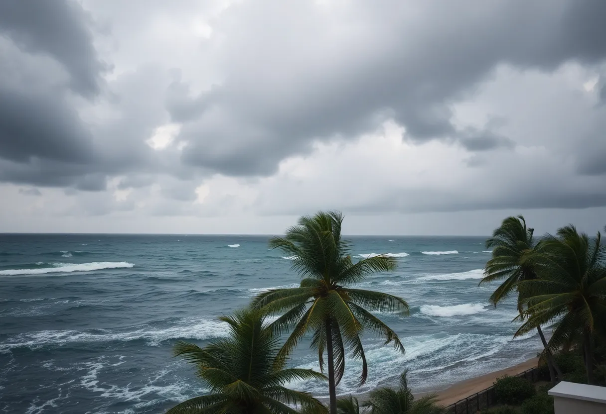
Coastal waters are also expected to experience dangerous conditions. High surf accompanied by breaking waves reaching between 6 to 8 feet presents serious hazards to boating and beach activities. A high risk of rip currents is forecasted along the coast, particularly from Sunday into Monday, further emphasizing the need for safety awareness in the waters.
Weather Alerts and Warnings
In response to the storm’s approach, Tropical Storm Watches are in effect for Coastal Martin, St. Lucie, and Indian River counties. Furthermore, Tropical Storm Warnings are active for waters from Jupiter Inlet to Deerfield Beach, as well as the Bahamas.
Impact Areas and Broader Outlook
While the storm’s immediate impacts are centered along Florida’s eastern coast, the weather system could influence broader regions later in the week. Rainfall and breezy conditions could affect parts of Georgia, the Carolinas, and Virginia early next week, with the potential for heavy rain, flash flooding, and mudslides especially in mountainous areas of the Caribbean and the southeastern U.S.
Preparedness and Local Response
Local authorities and school districts are actively monitoring the storm’s development. Currently, school districts within the Treasure Coast, including St. Lucie Public Schools, have not announced any closures for the upcoming school week. School officials are in close communication with the county’s Emergency Operations Center, prepared to adjust plans if the storm’s forecast changes.
Despite the expectation that the storm will remain offshore, families and individuals are strongly encouraged to stay informed by regularly checking the district’s official website, following their social media updates, and monitoring local news sources for any advisories or changes in the forecast.
Advice for Residents and Visitors
Residents are advised to review their hurricane preparedness plans and stay vigilant as the situation develops. The potential for heavy rain, high winds, and hazardous surf conditions makes it essential to keep safety precautions in mind, especially for those engaging in outdoor activities or near the water.
Officials warn residents to avoid ocean activities during peak wind and surf conditions and to exercise caution around coastal areas prone to rip currents and flooding. Preparing emergency kits, securing property, and staying informed remain critical during this period.
Background and Context
Tropical Depression Nine’s formation marks the early development stage of what could become a significant weather event along Florida’s Atlantic coast and the Caribbean region. Historically, storms that develop offshore can cause localized flooding, dangerous surf, and wind damage if they intensify closer to land. The storm’s path and strength will continue to be monitored in the coming days as officials assess potential risks and update the public accordingly.
While forecasts indicate the storm may stay offshore, unpredictable changes in its trajectory and strength mean residents and travelers in the area should remain alert until the threat passes.
Deeper Dive: News & Info About This Topic
HERE Resources
Additional Resources
- WPTV: Schools Monitoring Tropical Storm Watch
- Wikipedia: Tropical storm
- WPBF: Florida Tropical Storm Watch
- Google Search: Tropical Storm Watch
- Boca Raton Tribune: Tropical Depression Forms
- Encyclopedia Britannica: Hurricane
- Florida Today: Tropical Storm Watch Issued
- Google News: Tropical Depression Nine
Author: STAFF HERE WASHINGTON DC
The WASHINGTON DC STAFF WRITER represents the experienced team at HEREWashingtonDC.com, your go-to source for actionable local news and information in Washington, DC, and beyond. Specializing in "news you can use," we cover essential topics like product reviews for personal and business needs, local business directories, politics, real estate trends, neighborhood insights, and regional news affecting the area—with deep expertise drawn from years of dedicated reporting and strong community input, including local press releases and business updates. We deliver top reporting on high-value events such as the National Cherry Blossom Festival, Kennedy Center Honors, and the Washington Auto Show. Our coverage extends to key organizations like the Greater Washington Board of Trade and Destination DC, plus leading businesses in government contracting and technology that power the local economy such as Lockheed Martin and Amazon. As part of the broader HERE network, we provide comprehensive, credible insights into the dynamic landscape of the Washington metropolitan area.